
(This blog post covers work largely undertaken by Nigel Rothwell, one of our volunteers, and which was published in the Roman Roads Research Association Newsletter (behind a paywall I’m afraid) at the start of the year. We also gave a talk on the 23rd Feb on the subject, which might be repeated at some point – keep your eyes out if you missed it.)
Everyone loves a good Roman road, don’t they? Whether your knowledge of the Romans comes from academic literature or from Asterix, Lindsay Davis, history documentaries on TV and family holidays to Pompeii, everyone knows something about Roman roads.
The first thing you’ve probably been told is that they’re dead straight, ignoring topography in order to doggedly follow a surveyed alignment. The second thing you might have been told is that they were well-built, raised up on a bank (called an agger), with ditches either side for drainage, and built with multiple foundation levels and a high quality paved surface. These make up the characteristics we might expect for our prototypical “Roman Road.” Great fun can be had using maps and satellite imagery to try and spot Roman road alignments, taking lined-up roads, hedges, or parish boundaries as hints to their presence.

Chris Gunns / Roman road near Bainbridge / CC BY-SA 2.0
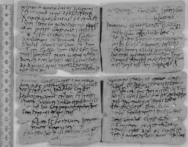
Whilst we aren’t going to tell you that prototypical Roman Road is entirely a fiction, such roads were almost certainly the exception, rather than the rule, in Roman Britain. Think of such roads as the motorways of the province, linking different regions and major cities. The far greater number and length of roads in Roman Britain were very different: smaller, less “Roman” in their character, and built to serve local needs rather than for marching legions. Road travel in the pre-industrial age was fraught with difficulties, and the quality of roads might be near the top of these. Even for the military in Roman Britain the poor quality of roads, and the variable conditions through the year, posed problems of transport and travel, as evidenced by Vindolanda Tablet 343:
“Octavius to his brother Candidus, greetings. …The hides about which you write are at Cataractonium – write that they be given to me with the wagon… I would have already been to collect them except that I did not care to injure the animals while the roads are bad.”
– Vindolanda Tablet 343, written between January 13th and March 1st sometime in the years AD 104-120
Let’s take a look at what we have found out about the Roman Roads, or rather, roads in use in the Roman period, crossing the Chilterns LiDAR survey area.
Major Roads – “A Roads”
A number of major roads cross the Chilterns, which we might term our “A Roads.” These were used to permit relatively long-distance, inter-regional travel, and were probably constructed by the Roman military or administration during, or soon after, the conquest period in the mid 1st Century AD. Examples include Watling Street (known in Roman Road studies as RR1) joining London to Wroxeter, Akeman Street (RR16) joining St Albans to Cirencester, and the Camlet Way (RR163) joining St Albans to Silchester.
(This numeric naming convetion comes from earlier scholars investigating the Roman roads of Britain, namely the “Viatores” researchers and their chairman Ivan Margary. The book Roman Roads in the South East Midlands, dating to 1964, by the Viatores, and Roman Roads in Britain, dating to 1973, by Margary, are seminal works, and the last major synthetic surveys to have been conducted in the region.)
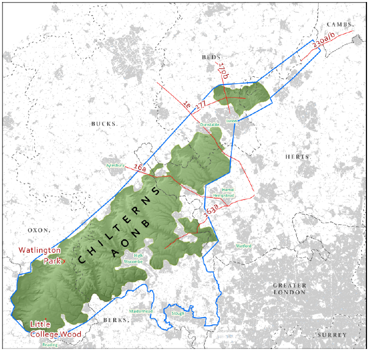
These major “A Roads” typically exhibit those classic characteristics of “Roman Roads” – they tend to be relatively straight for long distances, and they were, at least in part, built on embankments (aggers) and probably had roadside ditches along some of their length. For the most part though our view of these roads in the Chilterns is hindered by the fact that large proportions of their lengths lie under modern roads. For example the majority of Watling Street is, in our study area, beneath the A5183 as it runs northwards into Dunstable, and large parts of Akeman Street are beneath the A4251 through the centre of Berkhamsted.
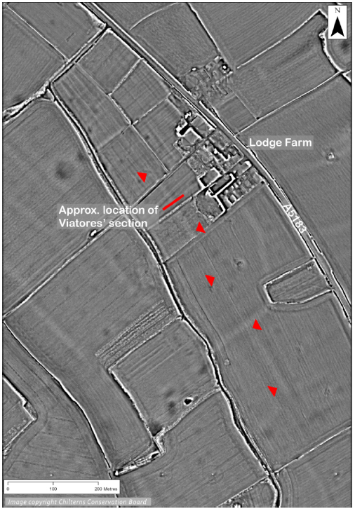
However, short sections of both of these roads are purported to lie in the open within our study area, and the LiDAR gives us a useful tool for investigating them. South of Dunstable, around the hamlet of Kensworth Lynch, the Viatores propose that Watling Street does not run underneath the A5183 curving along the bottom of the valley, but in fact runs through fields c. 100 m to its west, ignoring the topography. They even excavated a “section” through the road, and said that they had identified the road surface, on an agger, with wheel ruts in it. Using the LiDAR we can identify the slight embankment they had spotted in the fields, and it does seem to lie broadly on a true alignment for the road if it were to ignore the easy valley-bottom route. However, with the high sensitivity of the LiDAR and the visualisation techniques we can use for making even very slight earthworks stand out, it seems that this supposed agger only runs for a short way, and does not cover the full stretch it would need to. The possible conclusions – either 1) that even this most major of roads, Watling Street, was variable in its character and was not built for its full length on an embankment, or this did not survive, or 2) the Viatores had misidentified this feature and the real course of Watling Street remains at the valley bottom under the A5183; the feature they excavated, and which we can see in the LiDAR, is simply a field bank or a minor trackway. We can’t say for sure which conclusion is correct, but the LiDAR has added a useful new source of evidence to the puzzle.
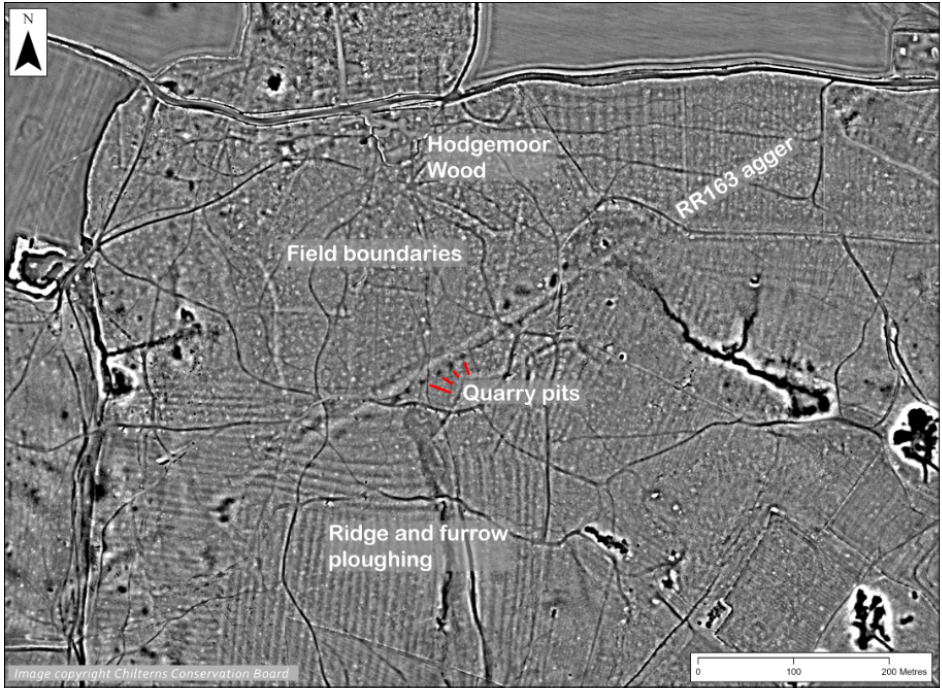
The biggest contribution the Beacons of the Past LiDAR has made to the conversation is the discovery of a well-preserved section of the “Camlet Way”, RR163, joining the two major towns of St Albans (Verulamium) and Silchester (Calleva). In 2017 a section of this route was identified in Environment Agency LiDAR at Pollard’s Wood, Little Chalfont, by David Staveley and published by John Gover in the Chess Valley Archaeological and Historical Society Journal. This demonstrated a possible new route for this road, some distance north of the route proposed by the Viatores. Beacons of the Past has, with the help of our Citizen Scientists, discovered a new section of road on the same alignment as that in Pollard’s Wood, this time in Hodgemoor Wood, Seer Green. This finding seems to confirm this new course of this road. We are hoping to publish a fuller article later this year on the detailed course of RR163, summarising all of the known evidence for its potential route between these two major towns.
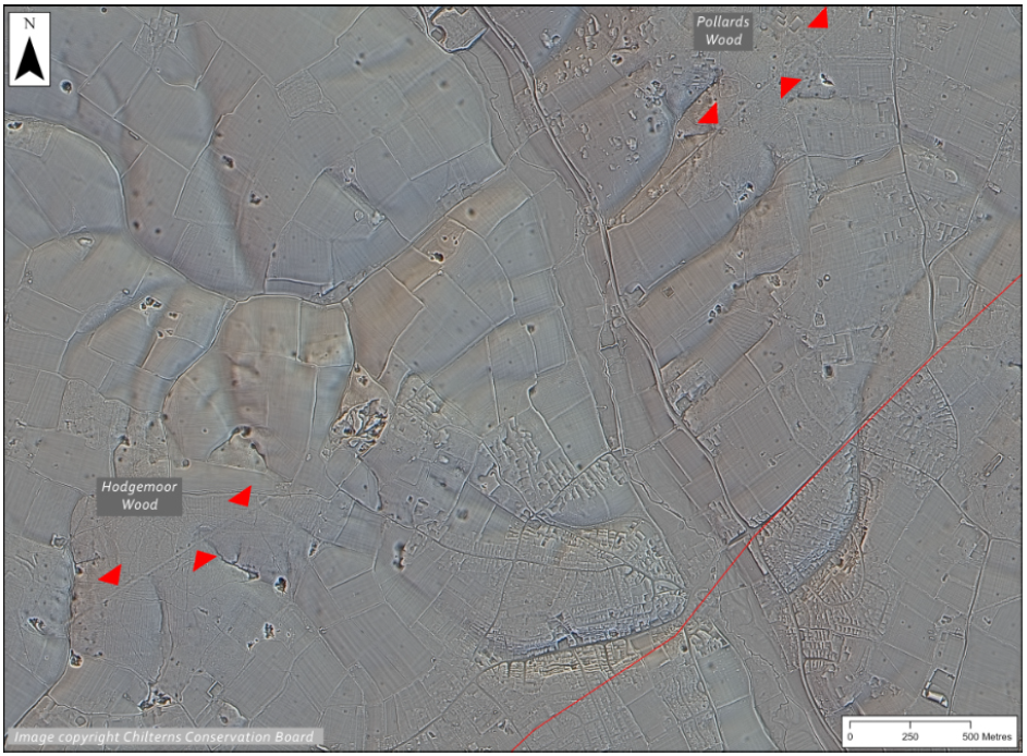
The LiDAR of Hodgemoor Wood shows a clear straight agger preserved in the woodland, along with roadside pits, presumably for quarrying of material for the construction of the road, and the faint outlines of an adjacent field system and a couple of ditched enclosures, which might potentially be contemporaneous with the road. Ridge and furrow ploughing shows that the road had gone out of use by the medieval period, before the land reverts to woodland sometime prior to AD 1600.
Minor Roads – “B Roads”
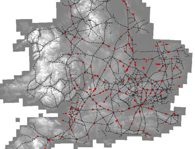
The South Midlands region stands out in maps of the Roman road network of Britain for the density of routes drawn. This is largely on account of the many roads identified by the Viatores in this region, who obviously paid it special attention. Several writers since have noted that many of these roads are likely to be relatively minor, and not truly part of the major road network traditionally illustrated.
When we enter the realms of these more minor roads we come up against a growing problem of defining what we mean when we use the term “Roman Road.” If we simply mean routes in use in the Roman period, then certainly many of these may well qualify, but if we are still looking for those physical characteristics of a prototypical “Roman road” then we start to lose our way slightly – many of these roads lack the tell-tale sign of aggers, roadside ditches, and straight aligments, and whilst it is plausible that the routes may have been used in the Roman period, we typically lack the clear evidence to say for certain whether such routes have their origins in prehistory, in the Roman period, or even in the medieval period.
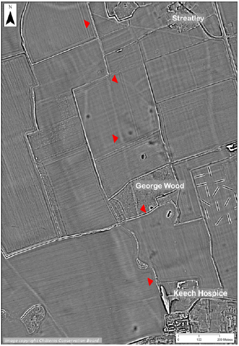
The LiDAR can however again play a useful role in proving or disproving some of these routes. For example route RR170, running north from Limbury, in Luton, to the walled small town of Irchester, in Northamptonshire, can clearly be seen in the LiDAR data with a straight aligment and well-preserved agger to the south west of Streatley, Beds., particularly in George Wood.
However, other of the Viatores routes appear to be somewhat speculative. For instance, Viatores route RR169a is mapped by them crossing Aldbury Common in Hertfordshire: this is a wooded landscape where we have excellent preservation of Late Iron Age and Roman rural settlement sites and trackways, visible in the LiDAR, and so we would expect a “B Road” linking them also to be apparent. However, no such route following the course they draw, even giving them some margin of error, can be detcted, and so this particular course can be discounted.
Trackways – “C Roads”
In our proposed hierarchy of routes the greatest number will be in the bottom category, “C Roads:” small trackways, probably only a single vehicle’s width, likely lacking a proper surface of any sort, and serving to connect inividual farmsteads and other rural settlement sites with their fields, and giving them access to the main road networks. By definition these routes, whilst the most numerous, will be hardest to discover, since they would have seen far less traffic than major roads and have far less “engineering” to leave an archaeological trace. In many cases they may be little more than a slight hollow, perhaps beside or between field boundaries, or a slight embankment left as a headland between cultivated fields, built of the flints cleared by the farm workers. Several examples seem to be characterised by frequent “dog-legs,” turning consecutive right-angled bends one way and then the other, presumably to skirt around fields. Given their slight nature they might typically only survive to be detcted by LiDAR in woodland, where they have been protected from modern ploughing. Dating such features is dependent on identifying a relationship with field systems and rural settlement in their vicinity.
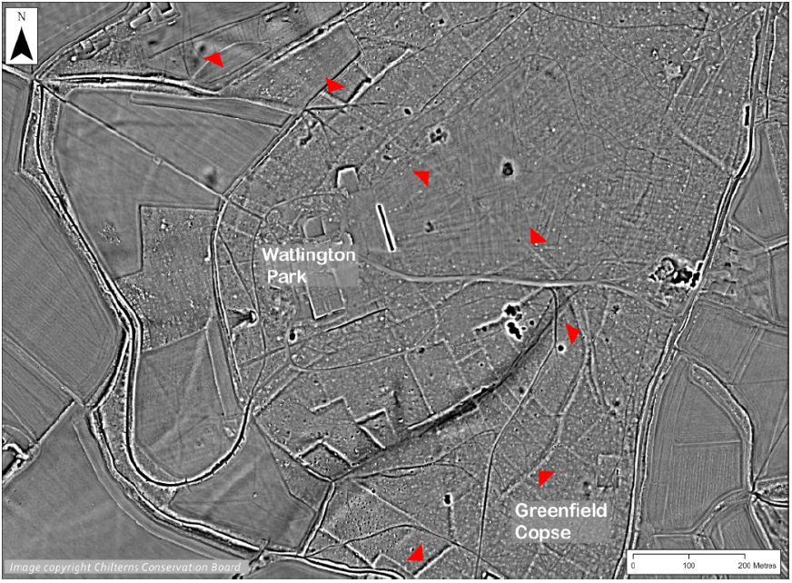
Several fantastic examples of this road type have been identified in the LiDAR data. For example at Greenfield Copse and Watlington Park, Oxon., a subtle negative earthwork can be seen in the midst of a possible later prehistoric or Roman field system, sometimes with a bank to just one side, and sometimes with banks on both sides of the hollow. As it runs down the escarpment the route appears on a slight embankment.
Conclusions
In sum, the high resolution LiDAR has provided a useful tool for reassessing the Roman roads of the region. The key take-away, we think, is one of complexity – to speak of “Roman roads” is simplistic and removes the great variability in character and function, and the act that many routes may well have been in use long before the Roman invasion, and some continued in use long after AD 410. Roads were not immutable – they might have been upgraded, repaired, or abandoned in favour of nearby parallel courses through time. The Roman military and administration probably were not involved in the organisation of any but the largest, most main of roads (our “A Roads”) through the region, with the rest created, mantained, and used by the local Romano-British population, and so whose histories were determined by multiple agents over multiple periods in a more organic, bottom up process with little over-arching organisation. Identifying whether a route had a prehistoric origin or a Roman origin is very difficult indeed, dating evidence likely only to come through association to nearby datable sites. It is still unknown whether the rural landscape of the Chilterns remained similar to its pre-conquest character, or if it saw significant reorganisation with the Roman invasion and the subsequent development of the economy of South East Britain and spread of villa culture.
The insight gained from this study will have significant bearing on understanding Romano-British life in the Chilterns – the nature of settlement, the rural economy, and the exploitation of the resources of the landscape are all important areas of study, into which a heightened understanding of the road and trackway network will play a crucial part.
Really interesting and the illustrations are so easy to understand.
I am sorry to have missed the original talk and hope that it will be repeated.
Thank you. Simon
Very illuminating. It would be interesting to know how many reputed Roman roads are actually Roman roads or just called that because they are straight. Do tithe maps show any more details?
Fasinating!
The density of minor roads is perhaps not so surprising when you consider how the military set-out their long, straight highways. As a highway engineer myself, I have never quite accepted that the Romans possessed the means to set-out something like the Fosse Way in an unmapped landscape. For example, starting from, say, Lincoln, how do you know that Exeter is south-west, and vice-versa? The knowledge must have evolved from a pretty good conception of direction and location by the preceding British population who, even if they had little understanding of the value of ‘straightness’, at least accepted the concept of compass points. So armed with a crude British feel for direction, and maybe a rough diagram on an animal hide, all your Roman general needs is a starry sky, a dozen or so bonfires, and enough time to shift things ‘a little to the left, or right’.